top of page

COMMONWEALTH WWII PAPER ITEMS


#PA5 D-Day IKE “Eisenhower letter”
Original Second World War Allied Expeditionary Force D-Day IKE “Eisenhower letter”. The D-Day letters were handed out to soldiers about to participate in the historic D-Day invasion 6 June 1944. The letter has been well preserved with the typical folds encountered on all of them and some yellowing, but overall it is in excellent condition. This D-Day related item is becoming increasingly hard to find. $425 *On Hold*


#WS16 Signed photograph of Bernard “Monty” Montgomery, 1906 Football Cup
Original period photo of Bernard “Monty” Montgomery of Alamein, including Monty's original signature. The photo shows a 19 year old Montgomery playing for the Wainwrights and winners of the 1906 Football Cup. Given the age, the cardboard must be handled with care, at some point one corner has broken off. Framing is recommended for display. Unique item from one of the most famous wartime Generals. $400
#MP95 Canadian Army Active postcard
Original Second World War Canadian Army Active postcard. Unused example with nice colours and a little bit of staining on the front as shown. $10


Second World War targetry
Target No. 6 "Disappearing Man" $10 / each
Target No. 9 "Small 200/30 yds." $10 / each
SOLD


"Operation Baytown" invasion map of Reggio Di Calabria, Italy
Original Second World War invasion map of Reggio Di Calabria, Italy. Used during the "Operation Baytown" amphibious landing as part of the Italian campaign where many Canadian units earned the "Landing at Reggio" battle honour with the 8th Army. The map was published by the Geographical Section of the War Office in 1943 with the defence overprint dated 24 August. This map is combat carried and shows the expected wear and age. *Sold*


"Operation Chesterfield" map, The Hitler Line, Pontecorvo, Italy
Original Second World War map of Portecorvo, Italy, with defence overprint. The map is dated May 1944 for use during "Operation Chesterfield" where the 1st Canadian Division would break through on The Hitler Line on the road to Rome. *Sold*
"KAPUT" The Maple Leaf
Original Second World War Canadian issue of "KAPUT" published by The Maple Leaf for Canadian Forces in Action. Significant edition marking the end of the War in Europe. Features include a full page cartoon of Canadian soldiers celebrating with liberated Lowenbrau beer and other war booty amongst the ruins of a defeated Germany. *Sold*


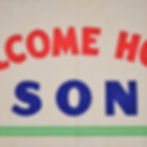

“Welcome Home Son” banner
Original Second World War Canadian “Welcome Home Son” banner. These would typically be displayed at the soldiers home after making a safe return from war. The Canadian War Museum has a similar banner in their collection here. Dated 1945 with A. Stevens copyright. The banner measures 18“ H x 36” W (Inches). The banner was likely period used and then put into storage, it’s still in nice shape with great colours. *Sold*
"GET TOUGH!" how to win in hand-to-hand fighting
Original 1942 copy of "GET TOUGH!" how to win in hand-to-hand fighting by then Captain W. E. Fairbairn. This is an early wartime edition of the publication as Captain Fairbairn was later promoted to Major and the later additions were printed to reflect his promotion. This is a lightly used copy in sound and readable condition without any damage. Captain Fairbairn would als be involved with development of the famous Fairbairn-Sykes fighting knife intended for close combat. *Sold*


EME. manual for the Canadian Inglis hi-power pistol
Original Second World War Canadian Electrical and Mechanical Engineers (EME) instruction manual for the Canadian Inglis hi-power pistol. Many of photographs and diagrams in Clive Law's book "Inglis Diamond" are from this manual. There are 25 double sided pages of information. *Sold*


"Operation Anger" map, Liberating The Netherlands
Original Second World War combat map of Arnhem (West) used by the Canadian First Army during the liberation of the city in 1945 as part of "Operation Anger". Second edition, this map was printed on the reverse of an obsolete map of Scotland with "CANCELLED" across the obsolete information. The War Department was facing paper shortages during this period and were forced to re-use old maps and captured maps to get the latest printings to soldiers at the front as quickly as possible. *Sold*


"Operation Anger" map of NIJMEGEN, emergency printing, The Netherlands
Original Second World War map of Nijmegen (West) emergency printing used by the Canadian First Army during the liberation of the city in 1945 as part of "Operation Anger". This map was printed on the reverse of an obsolete map of Scotland with "CANCELLED" across the obsolete printing. The War Department was facing paper shortages during this period and were forced to re-sue old maps and captured maps to get the latest printings to soldiers at the front as quickly as possible. *Sold*


"Operation Canada" map, DELFZIJL, The Battle for Delfzijl Pocket
Original Second World War map of DELFZIJL first emergency edition for "Operation Canada" also known as the Battle of Delfzijl Pocket to liberate this region of The Netherlands. This was the final battle of the Second World War that the 5th Canadian Armoured Division would participate in. The War Department was facing paper shortages during this period and were forced to re-sue old maps and captured maps to get the latest printings to soldiers at the front as quickly as possible. This map was printed on a captured German map of Sonderausgabe. *Sold*


"Bergen Op Zoom" map, Battle of The Scheldt
Original Second World War map used by Canadian soldiers who cleared the German occupiers out of Bergen Op Zoom during the famous Battle of The Scheldt. The map was printed by 3RCE in September 1944. *Sold*


"Operation Market Garden" map, 'S Hertogenbosch, NIJMEGEN
Original Second World War map of 'S Hertogenbosch to include NIJMEGEN. Printed in time for "Operation Market Garden" and possibly later used for "Operation Anger" to liberate The Netherlands. No printing on the reverse. *Sold*


#MI86 C/E “MAPS ONLY” escape package
Original Second World War air crew “MAPS ONLY” escape package. Waterproof package containing silk map C/E for Holland, Belgium, France, Germany (C) and Germany Protectorate Slovakia, Poland, Hungary (E). Overall very good condition, showing some age and patina with some staining to the package exterior. The map can be easily removed, unfolded, examined, and put back. *Sold*


Silk escape maps
Original Second World War silk escape maps. Issued to the Allied nations including Canada, England, and the United States. These maps were used by aircrew, parachutists, SOE, and anyone else who may have ended up stranded deep behind enemy lines. This set is carried and folded condition, without any damage, and good strong colours. *Sold*


"GERMANY" pamphlet for Canadian soldiers, Operation Varsity
Original Second World War pamphlet "GERMANY" for Canadian soldiers entering the enemy heartland of Germany during "Operation Varsity". The manual discusses how Canadian soldiers were to treat the German's and what tricks they may expect. This pamphlet is hard to find as most were destroyed. *Sold*


Universal Carrier stowage diagram
Original Second World War poster size Universal Carrier stowage diagram. Printed on heavy duty canvas, this would show soldiers where every piece of equipment would go inside of the vehicle. *Sold*
Arnhem / Nijmegen 40 West map
Original Second World War map of Arnhem / Nijmegen 40 West. This map would have been used during the Battle of Arnhem, and later in the liberation of the Netherlands. In the bottom left there is printed "10/FEB45/15.M.R.S/738/1017" which indicates the map was last intended for operations during the Canadian liberation of the Netherlands. *Sold*


German Weapons Illustrated
Original Second World War Canadian pamphlet “German Weapons Illustrated”. This publication was intended for use by formation and unit intelligence officers. Includes many interesting diagrams and photographs of captured equipment. *Sold*


Bremen Germany Bomber Command target map
Original Second World War RAF / RCAF Bomber Command target map of Bremen, Germany. The map shows interesting city features including shipyards, the autobahn, and aerodrome. Because of the key military industrial facilities for German war production, this was a high priority target for the RAF even in the early days of the war, and it was hit quite often. This was printed at the hydrographic and map service, Labelle Building, Ottawa, December 1941. Very good condition with strong colours. *Sold*
1st Canadian Infantry Brigade Sicilian Campaign sports guide
Original Second World War 1st Canadian Infantry Brigade Sicilian campaign sports guide. Interesting insight into the sports activities of the brigade during the campaign with nice graphics on the cover. *Sold*


bottom of page